Lab 03 - Reproducing Map - Geologic Map
Contents
1. Introduction
1.1 Geology of Cache County, Utah
1.2 Lab Objectives
2. Geologic Map of Cache County, Utah
3. Area Calculations
2.1 Extracting Information from Maps
2.2 Major Rock Units of Cache County, Utah
4. Adobe Illustrator Exercise
5. References
1. Introduction
1.1 Geology of Cache County, Utah
1.2 Lab Objectives
2. Geologic Map of Cache County, Utah
3. Area Calculations
2.1 Extracting Information from Maps
2.2 Major Rock Units of Cache County, Utah
4. Adobe Illustrator Exercise
5. References
Introduction
Geology of Cache County, Utah
There are many geologic formations in Cache County, Utah and this lab will attempt to uncover these formations by reproducing a professional map. This map will cover different sections of Cache County, Utah and expose readers to the rock formations contained in the valley. All relevant information has been reproduced below by mapping the area of interest for this lab. Detailed instructions for the lab can be found on Joe Wheaton's website.
Lab Objectives
- Learn how to manipulate display properties and symbology to reproduce a map in as close as possible a fashion to the original.
- Learn how to extract summary statistics and data from existing data.
- Learn how to make professional maps not just using ArcGIS, but by leveraging the power of a vector graphics application (e.g. Adobe Illustrator).
- Reproduce a portion of the
1:100,000 scale Logan 30’ x 60’ covering portions of Smithfield, Logan,
and Logan Canyon up to Wood Camp at 1:100,000 scale on an 8.5” x 11”
sheet.
Geologic Map of Cache County, Utah
The following map is what I submitted as a reproduction of the original map. Be advised that the reproduction I produced is of a smaller area and required less detail. It is also important to note that the 1:100,000 scale is only applicable if the map is printed as intended; on an 8.5" x 11" sheet of paper.
The following map is what I submitted as a reproduction of the original map. Be advised that the reproduction I produced is of a smaller area and required less detail. It is also important to note that the 1:100,000 scale is only applicable if the map is printed as intended; on an 8.5" x 11" sheet of paper.
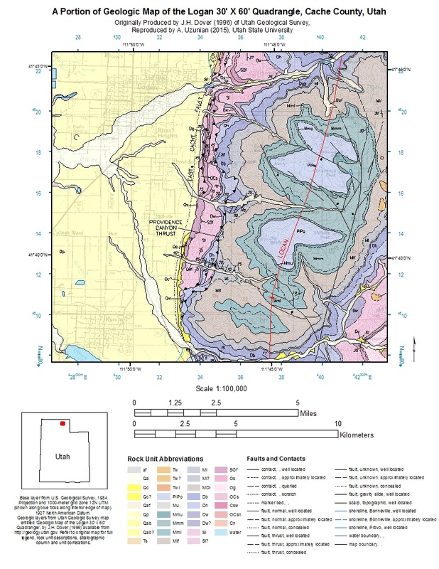
To download a pdf version of this map please click on the image or click here.
Area Calculations
Extracting Information from Maps
In order to make maps useful for analyses sometimes it is useful to extract specified information. There are a plethora of rock units contained in this map so it seemed useful to extract information based on a more narrow parameter. In this case, the assignment called for using total area covered (km 2) and calculating the percentage of the total map. I then singled out rock units that covered 5% or more of the map area and produced the following chart and report. Keep in mind that there are several different types of rock units below 5% km2 not included in the chart below, which is why the numbers will not add up to 100%. In fact the rock types not included add up to 26.631%.
Major Rock Units of Cache County, Utah
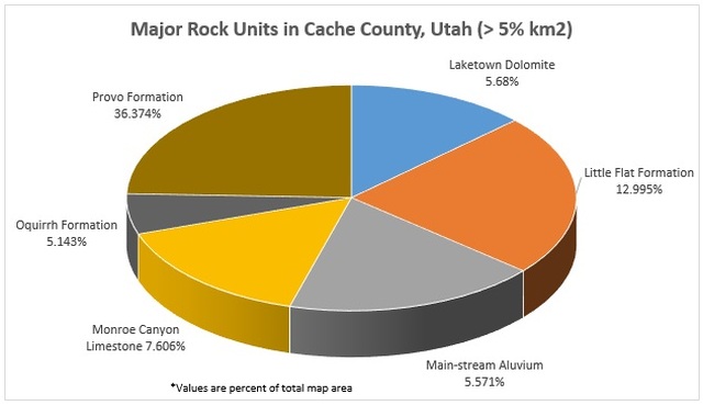
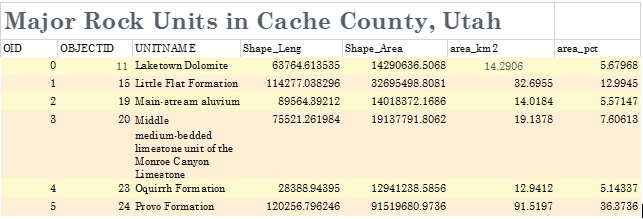
To download a Microsoft Excel version of this data please click here.
Adobe Illustrator Exercise
In order to produce really excellent maps it is oftentimes necessary to use tools outside of ArcGIS. Adobe Illustrator is a powerful editing tool that I used in order to make a closer replication of the original map. As this was the first time I have used Illustrator there are several components missing and the map is generally in draft form. But there are important differences in the map below compared to the one produced above, mainly the grid and graticule coordinates are not overlapping, I was able to use a different north arrow, and the rock types have their full names written out, rather than just symbols. The map could use further editing, but does give an indication of the possible uses of Adobe Illustrator.
In order to produce really excellent maps it is oftentimes necessary to use tools outside of ArcGIS. Adobe Illustrator is a powerful editing tool that I used in order to make a closer replication of the original map. As this was the first time I have used Illustrator there are several components missing and the map is generally in draft form. But there are important differences in the map below compared to the one produced above, mainly the grid and graticule coordinates are not overlapping, I was able to use a different north arrow, and the rock types have their full names written out, rather than just symbols. The map could use further editing, but does give an indication of the possible uses of Adobe Illustrator.
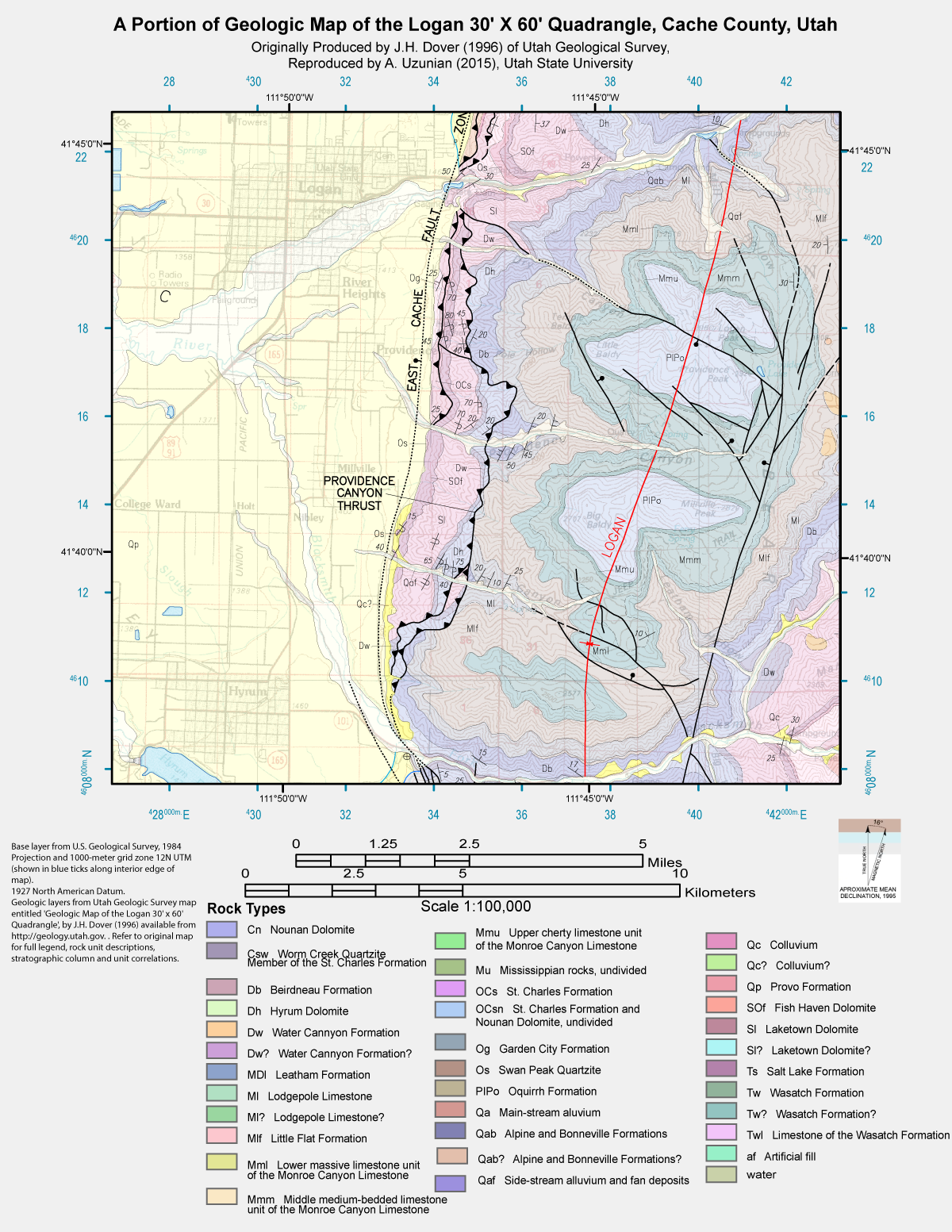
To view a larger version of the map please click on the image or click here.
